
Live Operations Feed
Updates publish in real time as operations status changes.
Friday, October 9, 2026
- Advisory
Isaias Makes Landfall Near Destin as a Category 2 Hurricane.
NHC confirmed that Hurricane Isaias made landfall near Destin, Florida, at about 9:30 PM EDT, based on National Weather Service Doppler radar. Maximum sustained winds at landfall were near 105 mph, a Category 2 hurricane. Isaias had weakened slightly from Category 3 in the final hours before landfall. The center is moving north at 19 mph, about 40 miles east of Pensacola and 50 miles west-northwest of Panama City. Reports from the coast: - A gust to 116 mph, with sustained winds of 91 mph, near Santa Rosa Sound. - A gust to 100 mph near Pensacola. - A water level of 5.6 feet above normal high tide at a gauge in Panama City Beach. NHC says life-threatening storm surge is affecting the Gulf Coast, and dangerous hurricane conditions and flash flooding are spreading inland. Hurricane-force winds could reach up to 100 miles inland into southern Alabama tonight. Tornadoes remain possible overnight across the Florida Panhandle, southeast Alabama and southern Georgia. Isaias should weaken quickly over Alabama and become post-tropical on Saturday. The worst of the storm passes overnight, but conditions will stay dangerous into Saturday morning. Flooded roads, downed power lines and debris will be the main hazards once the wind drops. FOR WHEELHOUSE IT CLIENTS Stay where you are tonight. Our monitoring is tracking which client sites have gone offline. Recovery starts Saturday as soon as local officials say it's safe, and your account manager will contact you directly about your locations. We monitor client sites, so when a location loses power or internet, we see it on our end. We still encourage you to report an outage when it's safe to do so. Hearing from you helps us confirm what our monitoring shows and rule out false alarms. Our 24/7 support line is (954) 474-2204. NOT A WHEELHOUSE IT CLIENT? - Stay off the roads tonight. - Don't go back to your office until local officials clear your area. - When you do go back, check for water and damage before you plug anything in, and wait until utility power is stable before turning equipment on. Our recovery checklist is free to download on this site. Our next update will be Saturday morning, with a focus on recovery.
Read full advisory → 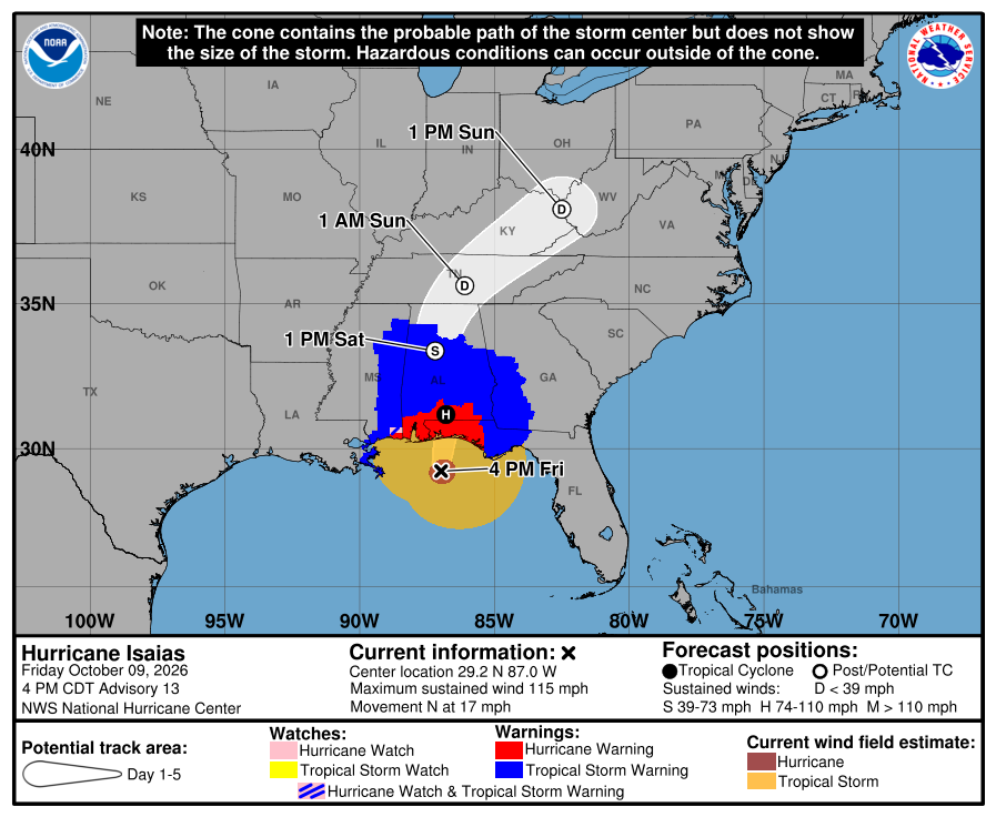 Advisory
Isaias Is 70 Miles From Pensacola. Landfall Expected This Evening.
As of NHC's 6:00 PM EDT update, the center of Isaias was about 70 miles south-southeast of Pensacola, moving north at 17 mph. It remains a Category 3 hurricane with maximum sustained winds near 115 mph. NHC's forecast models now agree on a landfall over the western Florida Panhandle near Pensacola this evening. Conditions are getting worse quickly. Recent reports include a 72 mph gust at Orange Beach, Alabama, a 69 mph gust at a NOAA buoy off Pensacola, a 58 mph gust near Gulf Breeze, and a 56 mph gust at Pensacola Naval Air Station. NHC says residents in the warning areas should be in safe shelter now. Hurricane conditions are expected this evening into early Saturday. NHC expects Isaias to be gustier than a typical hurricane at landfall, and because it is moving fast, strong gusts could reach well inland. Hurricane-force winds could extend up to 100 miles into southern Alabama. Isaias should weaken quickly after landfall and become post-tropical over Alabama by Saturday afternoon. The storm surge forecast is unchanged: 6 to 9 feet from the Alabama-Florida border to Grayton Beach, and 4 to 7 feet from Grayton Beach to Indian Pass. Tornadoes are possible tonight across the Florida Panhandle, southeast Alabama and southern Georgia. Rain totals of 4 to 8 inches, with localized amounts up to 15 inches, are expected across the region through the weekend. FOR WHEELHOUSE IT CLIENTS Our plan hasn't changed. Stay safe and stay off the roads. Our monitoring will show which sites go offline tonight, recovery checks start as soon as it's safe, and your account manager will check in after Isaias passes. Our 24/7 support line is (954) 474-2204. NOT A WHEELHOUSE IT CLIENT? - Stay where you are. Don't drive to check on your office. - After the storm, wait for local officials to clear your area before going back. - Don't power anything back on until the building is safe, any water is gone and utility power is stable. Our recovery checklist is free to download on this site. We'll post again when NHC confirms landfall.
Read full advisory →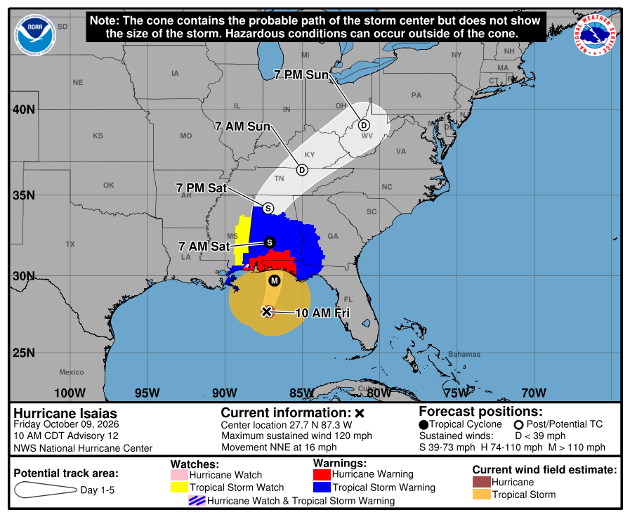 Advisory
Isaias Expected to Make Landfall This Evening on the Western Florida Panhandle.
Tropical storm conditions are beginning along the northern Gulf Coast. As of NHC's 2:00 PM EDT advisory, Isaias was a Category 3 hurricane with maximum sustained winds near 120 mph. The center was about 145 miles south of Pensacola, moving north-northeast at 16 mph. A gust to 47 mph was recently reported at Dauphin Island, Alabama. The track has shifted slightly east. NHC's latest forecast points to a potential landfall on the far western Florida Panhandle coast this evening, with Isaias at or near major hurricane strength. NHC says preparations against life-threatening storm surge and devastating winds should be completed within the next couple of hours. The storm keeps growing. Hurricane-force winds extend up to 35 miles from the center, and tropical-storm-force winds extend up to 205 miles. NHC expects hurricane-force winds to reach as far as 100 miles inland into southern Alabama, with hurricane-force gusts possible into central Alabama. Isaias should weaken after landfall and is likely to become post-tropical over northern Alabama by late Saturday. Storm surge forecast: - 6 to 9 feet from the Alabama-Florida border to Grayton Beach, including Pensacola, Navarre, Fort Walton Beach and Destin. - 4 to 7 feet from Grayton Beach to Indian Pass, including the Panama City area. - 4 to 6 feet from Dauphin Island to the Alabama-Florida border, and from Indian Pass to the Steinhatchee River. NHC says the tornado risk is greatest east of the center, across the Florida Panhandle and southern Georgia, starting this afternoon and continuing tonight. Rain totals of 4 to 8 inches, with localized amounts up to 15 inches, are expected across southern Alabama, the Panhandle and Big Bend, and southwest Georgia. NHC's guidance for people in the Hurricane Warning area is to have a safe room to ride out the storm and to prepare for long-duration power outages. FOR WHEELHOUSE IT CLIENTS Our plan hasn't changed. Nobody should go to an office during the storm, and we won't ask anyone to. Our monitoring will show which sites go offline tonight, recovery checks start as soon as it's safe, and your account manager will check in after Isaias passes. Our 24/7 support line is (954) 474-2204. NOT A WHEELHOUSE IT CLIENT? - If you're under an evacuation order, leave now. - Stay away from your office until local officials say it's safe to return. - After the storm, don't power anything back on until the building is safe, any water is gone and utility power is stable. Our recovery checklist is free to download on this site. Our next update follows NHC's 5:00 PM EDT advisory. NHC is also issuing hourly position updates now that coastal radars can see the eye.
Read full advisory →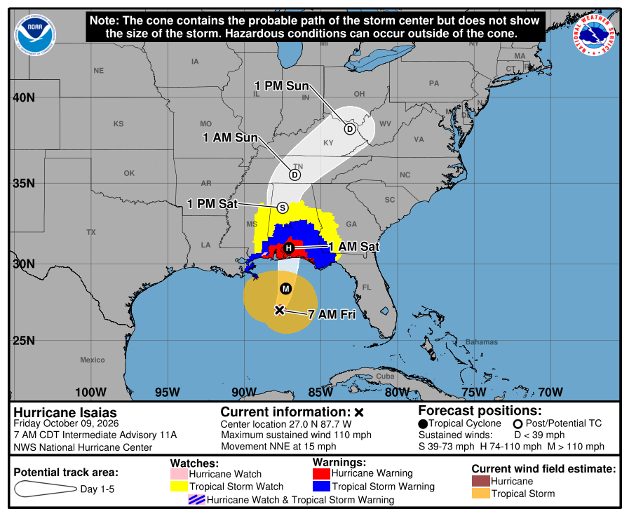 Advisory
Isaias Is Now a Major Hurricane. Surge Forecast Raised to 6 to 9 Feet Near Pensacola.
Isaias became a major hurricane this morning. At 8:20 AM EDT, NHC reported that Air Force Reserve Hurricane Hunters measured maximum sustained winds near 120 mph, making it a Category 3. The center was about 240 miles south of Pensacola, moving north-northeast at 15 mph. NHC expects Isaias to remain a dangerous hurricane at landfall this evening or tonight within the Hurricane Warning area. NHC also raised its storm surge forecast for the western Panhandle in a corrected 8:00 AM advisory: - 6 to 9 feet from the Alabama-Florida border to Grayton Beach. This stretch includes Pensacola, Navarre, Fort Walton Beach and Destin. - 4 to 7 feet from Grayton Beach to Indian Pass, including the Panama City area. - 4 to 6 feet from Dauphin Island, Alabama, to the Alabama-Florida border. - 4 to 6 feet from Indian Pass to the Steinhatchee River. NHC says preparations in the storm surge and hurricane warning areas should be completed within the next few hours. Tropical storm conditions are beginning, and hurricane conditions are expected this evening into early Saturday. Tropical-storm-force winds extend up to 185 miles from the center. Rain totals of 4 to 8 inches, with localized amounts up to 15 inches, are expected across southern Alabama, the Florida Panhandle and Big Bend, and southwest Georgia. Tornadoes are possible starting late this afternoon. NHC continues to warn of long-duration power outages in the Hurricane Warning area. Warnings are unchanged: a Hurricane Warning from Ocean Springs, Mississippi, to the Bay/Gulf County line, Florida, and a Storm Surge Warning from the mouth of the Mississippi River to the Suwannee River. FOR WHEELHOUSE IT CLIENTS Our plan hasn't changed. Nobody should go to an office during the storm, and we won't ask anyone to. Our monitoring will show which sites go offline, recovery checks start as soon as it's safe, and your account manager will check in after Isaias passes. Our 24/7 support line is (954) 474-2204. NOT A WHEELHOUSE IT CLIENT? - If you're in the storm surge warning area, follow local evacuation orders. Equipment can be replaced. - If you're still at an office in the warning area, shut down what you can in the next hour and leave. - After the storm, don't power anything back on until the building is safe, any water is gone and utility power is stable. Our recovery checklist is free to download on this site. Our next update follows NHC's 11:00 AM EDT advisory.
Read full advisory →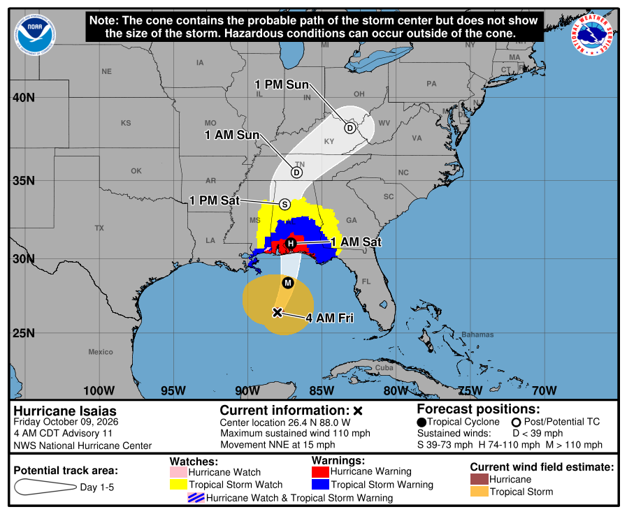 Advisory
Isaias Nears Major Hurricane Strength. Conditions Worsen Along the Gulf Coast Today.
Isaias strengthened overnight. As of NHC's 5:00 AM EDT advisory, Hurricane Hunters measured maximum sustained winds near 110 mph, the top of Category 2. NHC expects Isaias to become a major hurricane this morning and to peak near 120 mph this afternoon. The eye was about 200 miles south-southeast of the mouth of the Mississippi River, moving north-northeast at 15 mph. NHC expects stronger wind shear to weaken Isaias slightly before landfall. Its best forecast is a high-end Category 2 hurricane at landfall. NHC notes that if the shear arrives even six hours later than expected, a stronger hurricane could reach the coast. Landfall is forecast within the Hurricane Warning area tonight or early Saturday. The storm is now very large. Hurricane-force winds extend up to 30 miles from the center, and tropical-storm-force winds extend up to 185 miles. NHC says tropical storm conditions will begin in the warning areas within the next few hours, and that the weather will deteriorate quickly today. Hurricane conditions are expected tonight into early Saturday. Warnings in effect: - Hurricane Warning from Ocean Springs, Mississippi, to the Bay/Gulf County line, Florida. This includes Pensacola, Fort Walton Beach, Destin and Panama City. - Storm Surge Warning from the mouth of the Mississippi River to the Suwannee River. NHC now forecasts 5 to 7 feet from Dauphin Island, Alabama, to Indian Pass, Florida, and 4 to 6 feet from Indian Pass to the Steinhatchee River. - Tropical Storm Warning from the Jefferson/Plaquemines Parish line to west of Ocean Springs, and from east of the Bay/Gulf County line to the Aucilla River. Rain totals of 4 to 8 inches are expected across southern Alabama, the Florida Panhandle and Big Bend, and southwest Georgia, with localized totals up to 15 inches. NHC says flash flooding is likely. Tornadoes are possible starting late this afternoon along the Alabama and Panhandle coast. NHC continues to warn of long-duration power outages in the Hurricane Warning area. FOR WHEELHOUSE IT CLIENTS Today we move from preparation to monitoring. Once conditions arrive, nobody should go to an office to check on equipment, and we won't ask anyone to. Expect some sites to go offline tonight. Our monitoring will show us which ones, and recovery checks start as soon as it's safe. Your account manager will check in after Isaias passes. Our 24/7 support line is (954) 474-2204. NOT A WHEELHOUSE IT CLIENT? Tropical storm conditions are hours away in the warning area. - If you're still at the office, finish shutting down and unplugging equipment this morning, then leave. - Don't go back to check on equipment during the storm. - After the storm, don't power anything back on until the building is safe, any water is gone and utility power is stable. - If you use a generator, keep it outside and away from windows and doors. Our recovery checklist is free to download on this site. Our next update follows NHC's 11:00 AM EDT advisory.
Read full advisory →
Thursday, October 8, 2026
 Advisory
Isaias Is Now a Category 2 Hurricane. Its Wind Field Is Getting Larger.
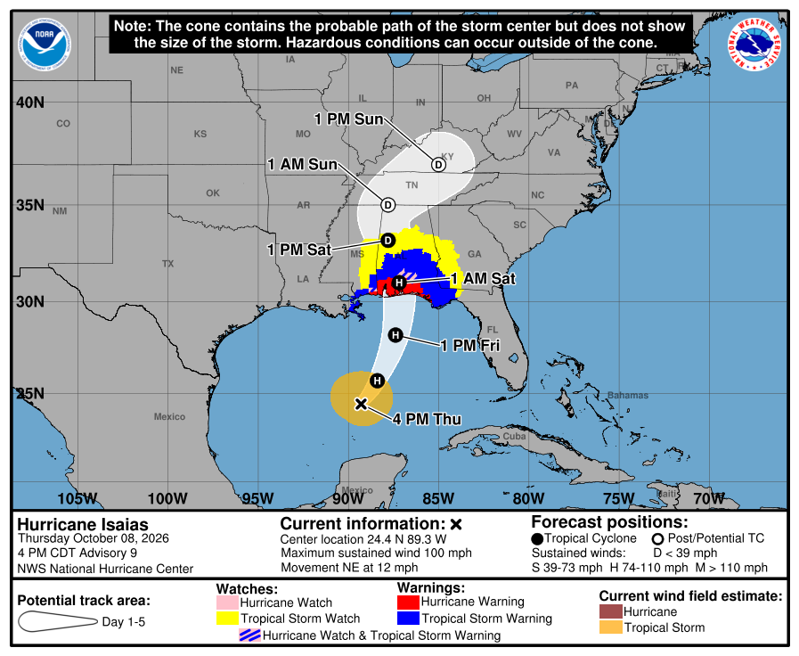
Hurricane Hunters found that Isaias strengthened this afternoon. As of NHC's 5:00 PM EDT advisory, maximum sustained winds were near 100 mph, making it a Category 2 hurricane. It has developed a clear eye, the first seen on satellite in the Atlantic this season. Isaias was about 325 miles south of the mouth of the Mississippi River, now moving northeast at 12 mph. The storm is also getting wider. Tropical-storm-force winds now extend up to 125 miles from the center, up from 90 miles this morning. That means conditions along the coast will deteriorate well before the center arrives. NHC expects Isaias to strengthen a bit more overnight, to near 110 mph, while it crosses very warm water. Stronger wind shear should then weaken it somewhat before landfall, but NHC says it will remain a dangerous hurricane, with strong gusts well inland after it crosses the coast. NHC nudged the track slightly east again this afternoon. Landfall is still forecast within the Hurricane Warning area late Friday or early Saturday. Rain totals increased again. NHC now expects 4 to 8 inches across southern Alabama, the Florida Panhandle and Big Bend, and southwest Georgia, with localized totals up to 15 inches in the Panhandle and Big Bend. It now says flash and urban flooding is likely, with considerable impacts possible. Warnings are unchanged: - Hurricane Warning from Ocean Springs, Mississippi, to the Bay/Gulf County line, Florida. This includes Pensacola, Fort Walton Beach, Destin and Panama City. - Storm Surge Warning from the mouth of the Mississippi River to the Suwannee River, with 5 to 7 feet forecast from Ocean Springs to Indian Pass and in Mobile Bay. - Tropical Storm Warning from the Jefferson/Plaquemines Parish line to west of Ocean Springs, and from east of the Bay/Gulf County line to the Aucilla River. Tropical storm conditions begin in the warning area on Friday, and hurricane conditions are expected Friday night into early Saturday. NHC continues to warn of long-duration power outages in the Hurricane Warning area. FOR WHEELHOUSE IT CLIENTS Nothing changes in our plan. Our team is working with clients in the warning area to finish preparations tonight, and our monitoring continues through the storm. We'll know which sites lose power or connectivity, and your account manager will check in after Isaias passes. If you need us tonight, call (954) 474-2204. NOT A WHEELHOUSE IT CLIENT? If your office is in the warning area, tonight is the last chance to finish. - Shut down, unplug and raise servers, network gear and battery backups. With up to 15 inches of rain possible, raise them even if you're outside the surge zone. - Photograph your equipment before you leave. - Forward your main lines and update your voicemail and website. - After the storm, don't power anything back on until the building is safe and utility power is stable. Our recovery checklist is free to download on this site. Our next update follows NHC's 11:00 PM EDT advisory, or Friday morning.
Read full advisory →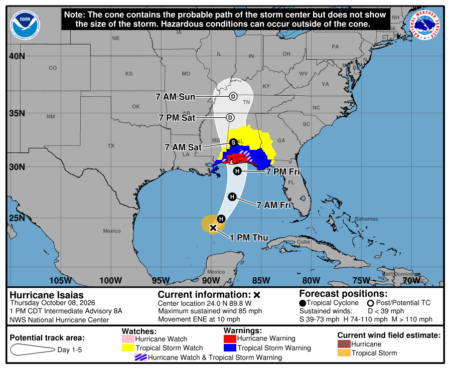 Advisory
Isaias Strengthening Ahead of Landfall. Rain Forecast Raised to 15 Inches in Spots.
As of NHC's 2:00 PM EDT advisory, Isaias had maximum sustained winds near 85 mph, up from 80 mph this morning. It was about 355 miles south of the mouth of the Mississippi River, moving east-northeast at 10 mph. NHC expects more strengthening through early Friday. Satellite images show signs that often come before rapid strengthening. NHC still expects wind shear to weaken Isaias somewhat as it approaches the coast, but says it will remain a dangerous hurricane through landfall. The track hasn't changed much since this morning. Landfall is still forecast within the Hurricane Warning area late Friday or early Saturday, followed by a turn inland across the Southeast that will carry strong winds well inland. Three changes since this morning: - Rain: NHC now says localized totals up to 15 inches are possible in bands across the Florida Panhandle and Big Bend. It expects considerable flash flooding across southern Alabama, the Panhandle and southwestern Georgia, along with river flooding, some of which could be significant. - Storm surge: the Storm Surge Warning now extends east to the Suwannee River, with a Storm Surge Watch from the Suwannee River to Yankeetown. - Inland wind: NHC says damaging gusts are possible across central and northern Alabama and parts of western and northern Georgia, and expects more wind watches and warnings for those areas later today. Warnings in effect: - Hurricane Warning from Ocean Springs, Mississippi, to the Bay/Gulf County line, Florida. This includes Pensacola, Fort Walton Beach, Destin and Panama City. - Storm Surge Warning from the mouth of the Mississippi River to the Suwannee River. - Tropical Storm Warning from the Jefferson/Plaquemines Parish line to west of Ocean Springs, and from east of the Bay/Gulf County line to the Aucilla River. Tropical storm conditions begin in the warning area on Friday, and hurricane conditions are expected Friday night into early Saturday. FOR WHEELHOUSE IT CLIENTS Preparation work with clients in the warning area continues this afternoon. Once the storm arrives, our monitoring tells us which sites lose power or connectivity, so we'll know where recovery is needed before offices reopen. After Isaias passes, your account manager will check in on each affected location. If you need us, call (954) 474-2204. NOT A WHEELHOUSE IT CLIENT? If your office is in the warning area and you haven't finished, use the rest of today. - The flood risk now reaches beyond the coast. With up to 15 inches of rain possible, raise equipment off the floor even if you're outside the surge zone. - Shut down and unplug servers, network gear and battery backups before you leave. - Photograph your equipment and network closet for insurance and recovery. - Forward your main lines and update your voicemail and website. - After the storm, don't power equipment back on until the building is safe and utility power is stable. Our preparedness and recovery checklists are free to download on this site. Our next update follows NHC's 5:00 PM EDT advisory.
Read full advisory →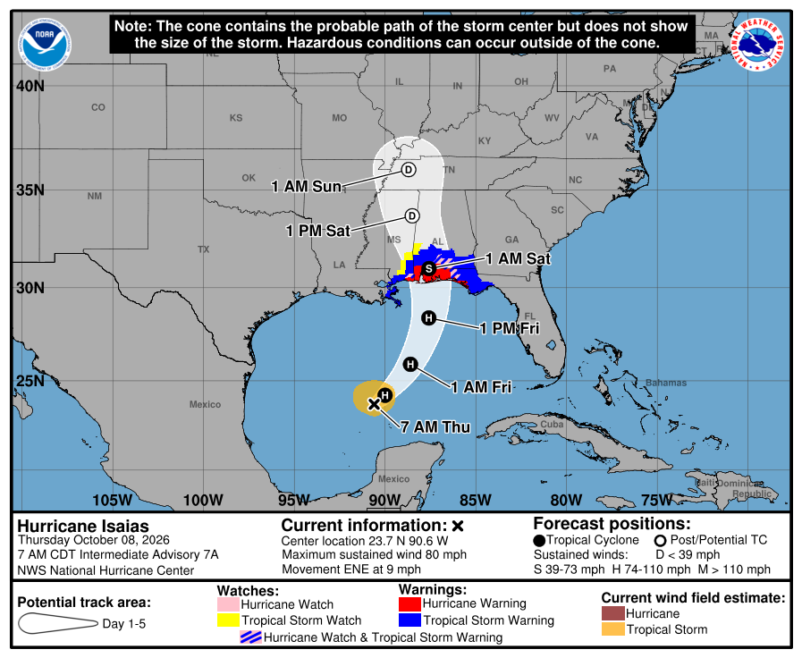 Advisory
Isaias Is a Hurricane. Hurricane Warning Issued from Mississippi to Panama City.
Isaias became a hurricane overnight, and NHC has upgraded the watches to warnings. A Hurricane Warning is in effect from Ocean Springs, Mississippi, to the Bay/Gulf County line in Florida. That includes Pensacola, Fort Walton Beach, Destin and Panama City. NHC says preparations to protect life and property in the warning area should be finished today. Warnings in effect as of NHC's 8:00 AM EDT advisory: - Hurricane Warning from Ocean Springs, Mississippi, to the Bay/Gulf County line, Florida. - Storm Surge Warning from the mouth of the Mississippi River to the Steinhatchee River, Florida. - Tropical Storm Warning from the Jefferson/Plaquemines Parish line, Louisiana, to west of Ocean Springs, and from east of the Bay/Gulf County line to the Aucilla River, Florida. - Storm Surge Watch from the Steinhatchee River to Yankeetown, Florida. At 8:00 AM, Isaias was about 385 miles south-southwest of the mouth of the Mississippi River, moving east-northeast at 9 mph with maximum sustained winds near 80 mph. NHC expects it to strengthen to near 110 mph by early Friday. Wind shear should weaken it some before landfall, but NHC expects Isaias to remain a dangerous hurricane, with a wind field that grows larger as it comes ashore. Gusty winds are expected well inland. Timing: tropical storm conditions begin in the warning area on Friday. Hurricane conditions are expected Friday night into early Saturday, and landfall is forecast within the warning area late Friday or early Saturday. Storm surge of 5 to 7 feet is forecast from Ocean Springs to Indian Pass, including Mobile Bay, with 4 to 6 feet from Indian Pass to the Steinhatchee River. NHC says to prepare for long-duration power outages in the Hurricane Warning area. Rain totals of 3 to 7 inches, with localized amounts up to 10 inches, are expected from far southeastern Louisiana to the Florida Panhandle. Isolated tornadoes are possible Friday night along the Alabama and Panhandle coast, spreading into eastern Alabama, Georgia and North Florida on Saturday. FOR WHEELHOUSE IT CLIENTS For clients with locations in the warning area, we're finishing preparations with you today, including shutdown timing, phone forwarding and remote access. Our monitoring continues through the storm, so we'll know which sites go offline and can start recovery as soon as it's safe. After Isaias passes, your account manager will check in on each affected location. If you need us today, call (954) 474-2204. NOT A WHEELHOUSE IT CLIENT? If you have an office in the warning area, today is the last day to prepare. - Shut down and unplug servers, network gear and battery backups before you leave. In the storm surge warning area, move them off the ground floor or out of the building. - Photograph your network closet and equipment before you go. The photos help with insurance claims and with getting back up afterward. - Confirm you have a current backup stored outside the region. - Forward your main lines and update your voicemail and website with how clients can reach you. - Plan for days without power, and have staff check in by text. - After the storm, don't power equipment back on until the building is safe and utility power is stable. Our preparedness and recovery checklists are free to download on this site. Our next update follows NHC's 11:00 AM EDT advisory.
Read full advisory →
Wednesday, October 7, 2026
 Advisory
Isaias Nears Hurricane Strength. Landfall Expected Late Friday or Early Saturday.
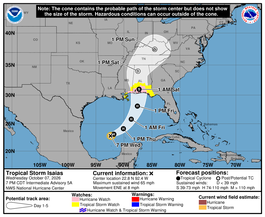
Isaias strengthened quickly this afternoon. As of NHC's 8:00 PM EDT advisory, maximum sustained winds were near 65 mph, up from 45 mph this morning. The storm was about 480 miles south-southwest of the mouth of the Mississippi River, moving east-northeast at 8 mph. Air Force Hurricane Hunters are investigating it tonight. NHC expects Isaias to become a hurricane by Thursday morning and keep strengthening through Friday morning. It now forecasts landfall along the U.S. northern Gulf Coast late Friday or early Saturday. NHC's 5:00 PM forecast shifted the track slightly east again and still calls for a strong hurricane as it approaches the coast. The watches from this morning remain in effect. NHC says additional watches and warnings could be issued for parts of the northern Gulf Coast tonight. - Hurricane Watch from Bay St. Louis, Mississippi, to Indian Pass, Florida. - Storm Surge Watch from the mouth of the Mississippi River to Yankeetown, Florida. - Tropical Storm Watch from the Jefferson/Plaquemines Parish line to west of Bay St. Louis, and from east of Indian Pass to the Aucilla River. Three forecast details changed since this afternoon. Surge east of the center went up: NHC now forecasts 4 to 6 feet from Indian Pass to the Steinhatchee River, alongside 5 to 7 feet from Ocean Springs to Indian Pass and in Mobile Bay. Rain totals rose to 3 to 7 inches, with localized amounts up to 10 inches, from far southeastern Louisiana to the Florida Panhandle. And NHC now mentions tornadoes, with the risk rising along the northeastern Gulf Coast Friday evening and spreading inland Saturday. Timing is unchanged. Tropical storm conditions could begin in the watch areas by midday Friday, and hurricane conditions late Friday. FOR WHEELHOUSE IT CLIENTS For clients with locations in the watch area, Thursday is our main preparation day. Your account manager and our engineering team will work with you on shutdown timing, phone forwarding and remote access before conditions worsen Friday. Monitoring continues around the clock, and we'll post here if watches become warnings. If you need us before then, call (954) 474-2204. NOT A WHEELHOUSE IT CLIENT? If you have an office in the watch area, Thursday is the day to finish. - Don't wait for a warning. A Hurricane Warning is usually issued about 36 hours before tropical-storm-force winds arrive, which leaves little daylight to act. - Shut down and unplug servers, network gear and battery backups before you leave. In a surge zone, move them off the ground floor. - Confirm you have a current backup stored outside the region. - Forward your main lines and update your voicemail and website with how clients can reach you. - Plan for a power outage that lasts days. Tell staff to check in by text, since calls often fail when cell networks are congested. Our preparedness checklists are free to download on this site. Our next update follows NHC's 5:00 AM EDT advisory Thursday, or sooner if warnings are issued overnight.
Read full advisory →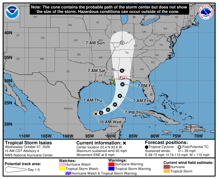 Advisory
Hurricane Watch Issued from Mississippi to the Florida Panhandle.
NHC issued a Hurricane Watch at 11:00 AM EDT from Bay St. Louis, Mississippi, to Indian Pass, Florida. That covers the western and central Florida Panhandle, including Pensacola, Fort Walton Beach, Destin and Panama City. Other watches issued at the same time: - Storm Surge Watch from the mouth of the Mississippi River to Yankeetown, Florida. - Tropical Storm Watch from the Jefferson/Plaquemines Parish line in Louisiana to west of Bay St. Louis. - Tropical Storm Watch from east of Indian Pass to the Aucilla River, Florida. At 11:00 AM, Isaias was about 540 miles south-southwest of the mouth of the Mississippi River, moving east-northeast at 8 mph with maximum sustained winds near 45 mph. NHC forecasts rapid strengthening and expects Isaias to be a strong hurricane before it approaches the northern Gulf Coast on Friday. It also expects the storm to grow in size as it gets closer. Tropical storm conditions could begin in the watch areas midday Friday, with hurricane conditions possible late Friday. That makes Thursday the last full day for outside preparations. NHC forecasts storm surge of 5 to 7 feet from Ocean Springs, Mississippi, to Indian Pass, including Mobile Bay, and 3 to 5 feet from Indian Pass to the Aucilla River. It is telling people in the surge watch area to follow local officials and evacuate if told to. In the Hurricane Watch area, NHC says to prepare for the possibility of long-duration power outages. Rain totals of 3 to 6 inches, with localized amounts up to 10 inches, are expected from far southeastern Louisiana to the Florida Panhandle Friday through the weekend. FOR WHEELHOUSE IT CLIENTS Account managers are contacting clients with locations inside the watch area today, and our engineering team is reviewing connectivity and remote access for those sites. Monitoring continues around the clock. If you have a location in the watch area and haven't heard from your account manager by the end of the day, call us at (954) 474-2204. NOT A WHEELHOUSE IT CLIENT? If you have an office in the watch area, use Thursday. - Plan for a power outage that lasts days, not hours. NHC is specifically warning about long-duration outages. - Before you leave Thursday, shut down and unplug servers, network gear and battery backups. In a surge zone, move them off the ground floor entirely. - Confirm you have a current backup stored outside the region. - Forward your main lines and update your voicemail and website with how clients can reach you. - Decide how staff will check in if they evacuate. Cell networks get congested after a storm, so text messages are more reliable than calls. Our preparedness checklists are free to download on this site. Our next update follows NHC's 5:00 PM EDT advisory.
Read full advisory →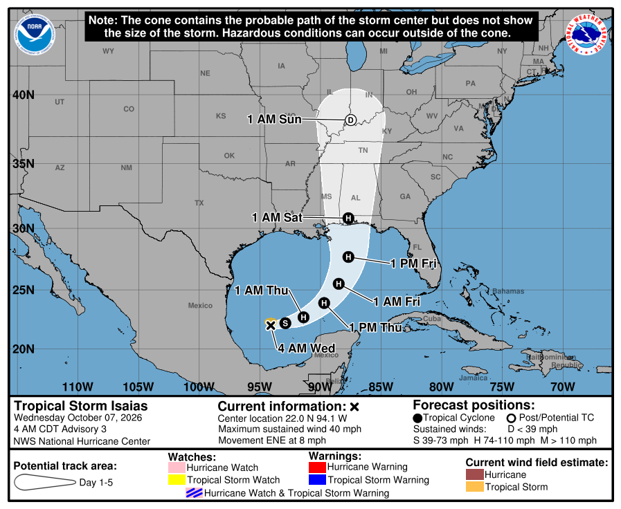 Advisory
Isaias Forms and Is Forecast to Strengthen Quickly. Hurricane Watches Likely Today.
Tropical Depression Nine became Tropical Storm Isaias overnight. As of NHC's 5:00 AM EDT advisory, Isaias was about 580 miles southwest of the mouth of the Mississippi River, moving east-northeast at 8 mph with maximum sustained winds near 40 mph. Two things changed overnight. NHC now forecasts rapid strengthening, with Isaias becoming a hurricane Thursday and peaking near 110 mph over the central Gulf. The forecast track also shifted east. NHC expects Isaias to approach the northern Gulf Coast on Friday and says it is looking more likely to be a significant hurricane when it reaches the coast. Track confidence is below average, so where it comes ashore can still change. No watches or warnings are in effect yet. NHC says hurricane and storm surge watches will likely be needed for part of the northern Gulf Coast later today, and it is telling residents from Louisiana to the Florida Panhandle to have their hurricane plans in place. NHC also expects rain and wind impacts to reach far from the center on the storm's eastern side, which is the Florida side. From Friday through the weekend, NHC expects 3 to 6 inches of rain, with localized totals up to 10 inches, from far southeastern Louisiana to the Florida Panhandle. Much of the Southeast could see 1 to 3 inches. Florida's state of emergency remains in effect for 25 Panhandle and Big Bend counties. FOR WHEELHOUSE IT CLIENTS Our monitoring continues around the clock, and your account manager will contact you directly if you have a location in the forecast area. When NHC issues watches, we'll post here and reach out to clients with locations inside the watch area. If you have an office along the northern Gulf Coast and want to talk through your plan, call us at (954) 474-2204. NOT A WHEELHOUSE IT CLIENT? If you have an office from Pensacola to Panama City, today and Thursday are your preparation window. A hurricane watch means hurricane conditions are possible within 48 hours. - Run a full backup today and confirm a copy is stored outside the region. - Decide by Thursday afternoon whether the office will close, and tell staff how they'll hear about it. - Before you close, shut down and unplug servers and network gear, and move equipment off the floor and away from windows. - Forward main phone lines to cell phones or a remote answering service. - Keep your internet provider, phone carrier and key vendor contacts somewhere you can reach without the office network. Our next update follows NHC's 11:00 AM EDT advisory, or sooner if watches are issued.
Read full advisory →
Tuesday, October 6, 2026
- Advisory
Florida Declares a State of Emergency for 25 Panhandle and Big Bend Counties.
Governor Ron DeSantis signed Executive Order 26-202 Tuesday evening, declaring a state of emergency for 25 counties in the Panhandle and Big Bend ahead of Tropical Depression Nine. The order lets the Florida Division of Emergency Management stage resources before the storm arrives. The state says generators, fuel and flood barriers are being staged in Tallahassee and the Santa Rosa area. The 25 counties are Baker, Bay, Calhoun, Columbia, Dixie, Escambia, Franklin, Gadsden, Gilchrist, Gulf, Hamilton, Holmes, Jackson, Jefferson, Lafayette, Leon, Liberty, Madison, Okaloosa, Santa Rosa, Suwannee, Taylor, Wakulla, Walton and Washington. A state of emergency is a preparedness step. It isn't an evacuation order, and it doesn't change the forecast. As of NHC's 5:00 PM EDT advisory, there are no coastal watches or warnings, and the depression is forecast to approach the U.S. northern Gulf Coast on Friday. Evacuation and closure decisions come from county emergency managers, so your county is the source to follow. FOR WHEELHOUSE IT CLIENTS We've checked our client locations against all 25 counties. If you have a location in one of them, your account manager is reaching out directly. Monitoring continues around the clock, and nothing changes for client locations outside these counties. NOT A WHEELHOUSE IT CLIENT? If you have an office in one of these counties: - Find where your county posts evacuation and closure orders, and sign up for its alerts tonight. - If you decide to close the office, shut down and unplug servers and network equipment before you leave. Don't count on a battery backup to ride out a long outage. - Make sure someone outside the area has your vendor and internet provider contacts in case local staff can't be reached. The checklist in our 5:00 PM update still applies. Our next update follows NHC's advisories Wednesday morning, or sooner if watches are issued.
Read full advisory → 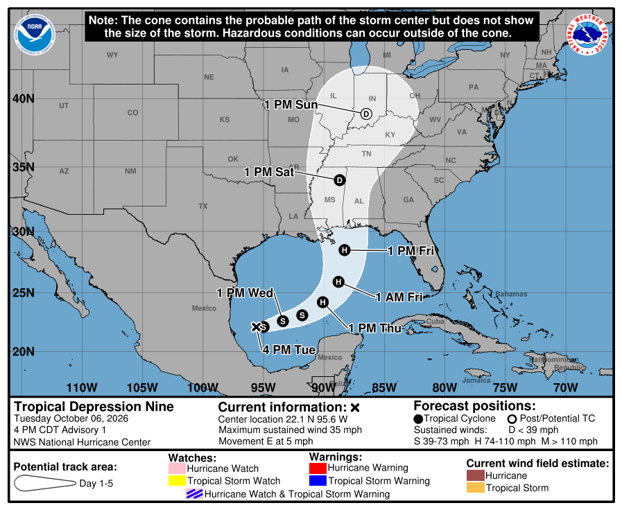 Advisory
Tropical Depression Nine Forms in the Gulf. Hurricane Strength Forecast by Thursday.
The National Hurricane Center began advisories on Tropical Depression Nine, formerly Invest 92L, at 5:00 PM EDT. At that time the center was about 630 miles southwest of the mouth of the Mississippi River, moving east at 5 mph with maximum sustained winds near 35 mph. NHC forecasts steady strengthening. It expects the depression to become a tropical storm by early Wednesday, at which point it would be named Isaias, and a hurricane on Thursday. The forecast track runs east to east-northeast for the next couple of days, passes north of the Yucatan Peninsula on Thursday, then turns northeast toward the U.S. northern Gulf Coast on Friday. There are no coastal watches or warnings in effect. NHC is asking interests along the U.S. northern Gulf Coast to monitor the system closely. Rain is the most certain impact. From Friday through the weekend, NHC expects 3 to 6 inches, with localized totals up to 10 inches, from southeastern Louisiana to the Florida Panhandle. Flash and urban flooding are possible, along with isolated river flooding. For the Panhandle, that rain lands on ground that has already been soaked for a week. FOR WHEELHOUSE IT CLIENTS We're tracking this storm against every client location in the Panhandle and along the northern Gulf Coast. Our monitoring continues around the clock, and your account manager will contact you directly if a location needs attention. If NHC issues watches that include the Panhandle, we'll post here and reach out to clients with locations in the watch area. NOT A WHEELHOUSE IT CLIENT? NHC's forecast brings this system toward the northern Gulf Coast on Friday. If you have offices from Pensacola to Panama City, that leaves Wednesday and Thursday to get ready. - Confirm your backups completed, then test restoring something that matters. - Decide now who makes the call to close an office, and how staff will hear about it. - Test remote access from outside the office while the building is open. - Get servers, network gear and battery backups off the floor of ground-level rooms. - Save your internet provider's and phone carrier's outage numbers somewhere other than the office. Our preparedness checklists are free to download on this site. Our next update follows NHC's advisories Wednesday morning, or sooner if watches are issued.
Read full advisory →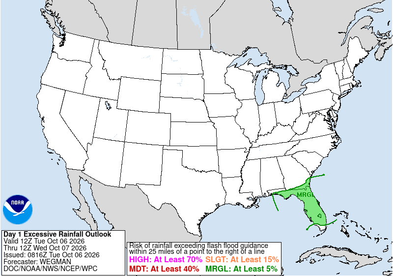 Advisory
92L Likely to Become a Depression. North Florida Gets More Rain Today.
The National Hurricane Center's 2:00 AM EDT outlook says Invest 92L, the disturbance in the southwestern Gulf, is likely to become a tropical depression within the next couple of days. NHC puts the odds at 80 percent through both 48 hours and seven days. Monday afternoon, the 48-hour number was 60 percent. NHC expects the system to drift east-northeast through the middle of the week, then turn north. It says it's still too early to know what that means for the northern Gulf Coast. No watches or warnings are in effect. If it reaches tropical storm strength, it will be named Isaias. In Florida, the rain matters more than the tropical system today. The National Weather Service in Jacksonville has a Flood Watch for Northeast Florida from 10:00 AM to 8:00 PM, with 3 to 5 inches of rain possible in spots. The stalled front is expected to sit near the Big Bend and the First Coast on Wednesday. Later in the week, the flash flood risk spreads into Central Florida and parts of South Florida. FOR WHEELHOUSE IT CLIENTS We've identified every client location in the forecast area. Backup status and system monitoring for those locations are part of our standard pre-storm checks, and our team watches client networks around the clock. If a site loses power or internet, we'll see it on our end and follow up. If anything at your location needs your attention, your account manager will contact you directly. Nothing about how you operate needs to change today. NOT A WHEELHOUSE IT CLIENT? If you have offices in North Florida or the Panhandle, today is a good day to: - Confirm your last backup actually completed, and that someone knows how to restore it. - Test remote access from outside the office while the building is still open. - Get servers, network gear and battery backups off the floor of any ground-level room. - Tell staff they can work remotely instead of driving through standing water. Our preparedness checklists are free to download on this site. Our next update follows NHC's afternoon outlook, or sooner if NHC starts issuing advisories.
Read full advisory →

Need direct contact during a storm event?
WheelHouse IT clients receive direct notifications. For active incidents, contact your account team or use the form.